 LAST PAGE
 RETURN TO INDEX
THE EARTHEN BANK
Part Fifty-two
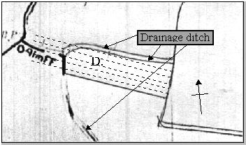
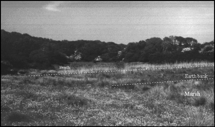
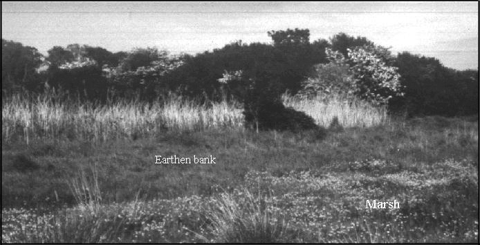
After the elementary excavation in the summer of 1993 the site was covered in soil and a closer examination made of the geology of the inlet. Only relatively late in this investigation did I realise the fact that the inlet was in fact closed by an earthen bank. This is drawn on the plan on page 134 as (D). It is positioned right under a huge bed of reeds, which runs across the entrance. I had spent half a year or so wandering around this site but had never seen the earthen bank. This is because you have to be on the marsh side of the inlet to be able to see it, or have to have walked to the very end of Sandrock Field. Even then it is not easily recognised because the reed bed hides the different height levels of the marsh and the inlet.
I had assumed upon casual inspection that this was something to do with the modern drainage ditches running throughout the marsh region. However this could not be so because checking the tithe maps showed the drainage ditch alongside the bank followed the same route in 1844.

The ditch ran across the front of the inlet completely contrary to logic if installing drainage with an open access. The conclusion is that the earth bank must have been in existence when the drainage was put in, because it was necessary to run the ditch across the front inside edge. If it had not been there the drainage would have been directly through the centre of the bank or more likely down the eastern side of the inlet, where the water runs deepest. The western side must have been chosen by the engineers of the time because this was where the water ran out of the inlet, because the bank was lowest on the this side, causing the water from the stream to come out this side. Only when the ditch was dug did they realise that the marsh inside the inlet needed additional drainage, requiring an extension of the ditch inside the inlet.

Looking north into Monkham inlet mid summer.
The earthen bank is not of the same construction as the other drainage ditches on the marsh. It is lower and more weathered. At this time I have no conclusive evidence that confirms it’s age. However Simon Jennings and Christine Smyth of the Archaeology Department of the University of London have conducted bore hole tests to see if this can be achieved. They are currently seeking a grant to do this work in conjunction with other work connected with the discoveries relating to industrialisation of the valley.

View of earth bank at Monkham inlet from marsh side looking north-east
The significance of this bank is that it provides the answer to one of history’s great dilemmas. This is how to explain how William was supposed to have burnt his boats (the Battle Abbey Chronicle) and yet earthed them up or decommissioned them (the Carmen). This anomaly has always forced historians to conclude that one version must have been an invention, forcing historians into separate camps, as to which version was authentic. The discovery of charcoal at the site of the Mora next to the “boat parts” leads to the conclusion that William may have burnt his boat, as well as some of the commanders, as a token of their commitment. However the very low mounds that are present along the western shore, which respond to dowsing, suggest that this is not true of the complete fleet. It is therefore quite likely that this mystery can be explained by the fact that the Battle Abbey record referred only to William’s boat, whereas the inlet itself was earthed up, confirming the Carmen version of events. The consequence of this observation being that for the first time in history a hypothesis can be rendered concerning the events of the Invasion that show both manuscripts to be a completely truthful version of the events, with the inference that each is equally authentic. The interpretation has been incorrect to date because the complete circumstances were unknown, as well as the location.
The full extent of the landing site is shown on the diagram in part 29, stretching westwards from the inlet as far as Decoy Pond, at the end of field numbers 841 and 842. This area is all designated SSSI and virtually impossible to obtain access to by the public. A lane has been built from this main landing site, which runs from the crook in the bay, directly to Wilting Manor house. This is called Cow Lane, most probably because it is used to deliver the cows to and from the marsh each year for grazing.
NEXT PAGE
 RETURN TO INDEX


 LAST PAGE
 RETURN TO INDEX

